|
Year
|
Route Historical Timeline
|
Highway number designation present day
|
|
1793 � 1812
|
North West Company began to explore west across the Rocky Mountains. Alexander Mackenzie was seeking a river route to the Pacific to reduce the high cost of shipping furs across the continent. The Nuxalk-Carrier 'grease' trail had existed for centuries, and was followed by Mackenzie in 1793. The trade route was in use for packing the much valued Eulachon oil, from Bella Coola on the coast, to the interior of the Colony (Fort Alexandria).
|
hwy #20 (region)
|
|
1808
|
Simon Fraser was yet another explorer with the North West Company and in 1808, followed the Fraser River to the Pacific Ocean, made possible only with assistance and guiding by local Indigenous peoples, using established First Nation trail and route networks.
|
#1 Trans Canada (region)
|
|
1848
|
The Anderson Brigade Trail, was used briefly by the Hudson's Bay Company. The trail began at Fort Yale, crossed the river at the narrows at Spuzzum and continued to Merritt. It was the first attempt post-contact to establish a route through the Canyon. Above the old 'Alexandra Lodge' site, the trail climbed a steep hill above the canyon to 'Lake House', and on to Fort Kamloops. Anderson's trail also utilized, and connected with, a First Nation�s pack trail, that linked Boston Bar to Merritt, (North Cascades).
|
#1 Trans Canada - #5 (region) - #5a (region) #97c (region)
|
|
1849
|
Hope - Tulameen brigade trail. A route to Fort Kamloops (via Nicola Lake) from 1847 to 1849, and later in 1858 and again in 1882, as a route to Boston Bar. The original First Nation trail proceeded NE of Hope, to the Tulameen River area, through to Nicola Lake (Merritt), then on to 'Fort Kamloops' at the confluence of the North and South Thompson Rivers.
|
#3 - #5a - #5
|
|
before 1858
|
First Nation trails were predominant at this time. Later, fur brigade trails used by the Hudson's Bay Company (HBC) to transport furs down to their Pacific Coast out-posts were established.
|
#1 - #5
|
|
1850's
|
Cayuse War between Native Americans and American soldiers began in 1847 and was still raging in Washington Territory in the late 1850's, and would impact Colony trail, and road construction routes during the gold rush years. This resulted in ocean based access routes from the south, instead of inland routes via the 'Okanagan'. At Fort Victoria, mining permits were required by all travellers enroute to the goldfields.
|
n/a
|
|
1858
|
Fraser Canyon Gold Rush, aka the Fraser gold rush, began after gold was found on the Thompson River at a tributary, the Nicoamen River, several kilometers upstream from the Fraser River and Thompson River confluence, at present-day Lytton.
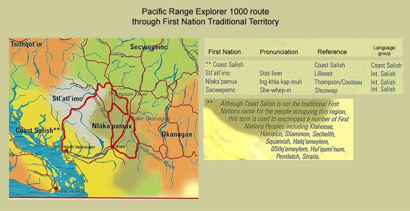
The Fraser Canyon War, also known as the Canyon War or the Fraser River War, took place in the fall of 1858 during the Fraser Canyon Gold Rush in the newly-declared Colony of British Columbia, which would later become a province of Canada. The conflict involving the Nlaka'pamux people (pron. Ing-khla-kap-muh), heavily influences route location and construction, during the gold rush years. The routing of the Douglas Trail (1861), is an example of this colonial government's policy.
|
#1 Trans Canada
|
|
prior to 1859
|
The Cayoosh Pass/Duffey Lake/Melvin Creek, and the Cayoosh Creek Valley, was historically used as a travel route for trade, and traditional hunting/gathering area of the Stl'atl'imc people (pronounced: Stat-liem), and is within their Traditional Territory.
|
#99
|
|
1859
|
Governor James Douglas, commissions the construction of a road ( 4 foot wide mule trail). A goldseekers route From the Coast (Fraser Valley) to the Interior (Fort Alexandria).
|
#99 Pemberton Valley/Lillooet Lk
|
|
1860
|
The Cayoosh Range is traversed by Sapper James Duffey of the Royal Engineers, who investigated it as a possible overland alternative to the Douglas Road. It was dismissed in favour of the Anderson Lake/Seton Lake route accessed via trail from the Pemberton Valley.
|
#99 Pemberton Valley/Lillooet Lk
|
|
1860
|
First Nation trails preceded the Dewdney trail east through the Cascade Range, (Hope to Similkameen). The Dewdney trail was built eastward to access the gold rush in Rock Creek, that was being supplied by the American merchants, as the access from the south was available. Governor James Douglas, for the financial benefit of merchants in New Westminster and Fort Hope, commissioned a wagon trail. The Royal Engineers surveyed the area. Edgar Dewdney was hired to construct the wagon road - to be 4 feet wide and no steeper grade than �one in twelve�. The trail was completed to the town of Princeton.
|
#3 Hope-Princeton
|
|
1860
|
Gold discovered on William's Creek, in the Cariboo country.
|
hwy #97 (region)
|
|
1861
|
The Douglas Road to Lillooet (also known as the Lakes route or Harrison trail) is completed. From the mouth of Harrison River, across Harrison Lake (paddlewheel steamer). An overland trail along the Lillooet River, then across Lillooet Lakes by vessel to Port Pemberton. A long portage via the mouth of the Birkenhead River (near present-day Mount Currie), to Anderson Lake (D'arcy). The length of Anderson lake by canoe or steamer. A short portage to Seton Lake (1 1/2 miles). Across Seton Lake by steamer or canoe to the foot of the lake, then a final 5 mile wagon road descent to the Fraser River and former Stl'atl'imc village site, where the gold rush 'boomtown' of Lillooet was built on top of. The entire length of trail from Port Douglas was nearly 100 miles.
|
#99 Pemberton Valley/Lillooet Lk
|
|
1861
|
The other 'Cariboo Road' is informally applied to a toll-road built by contractor Gustavus von Blint, that extended north from Lillooet to Fort Alexandria (via Pavillion road). It was also known as the �old Cariboo wagon road�.
|
#99 - previously designated #12
|
|
~1861
|
The "River Trail" was a main route for travel in the colonial era of British Columbia, running northwards along the Fraser River from to present day Lillooet to Big Bar, and points beyond in the Cariboo District. The trail was the choice for most prospectors and travellers heading north from Lillooet who could either not afford the tolls of the Old Cariboo Road, or had no need of it as the River Trail sufficed for foot-travel or horse travel with small pack-trains. The wagon roads were built for freight wagons and stage travel, and also went up and over mountains and plateaus which travel via the River Trail did not require.
|
#99 (region)
|
|
prior to 1862
|
A route existed through the lower Fraser Canyon, referred to as a mule trail, which was a rough-hewn cliff-side trail wide enough only for one mule that would become the approximate route of the future Cariboo road.
|
#1 Trans Canada
|
|
1862
|
On March 13, 1862, a passenger bound for the goldfields stepped off the steamer Brother Jonathan in Victoria and brought death to tens of thousands on Vancouver Island and in British Columbia. The miner had smallpox. Aboriginals were forced out of Victoria, returning to their villages, where its estimated that 30,000, half of Vancouver Islands Native population died from the disease. It soon spread over to the capital of the mainland colony of B.C., then accompanied the miners inland to the gold camps.
|
n/a
|
|
1862
|
June 25: Lt. Herbert Palmer, and two other Royal Engineers, map a proposed up-coast road, following an existing Traditional Aboriginal route from Bella Coola, at the end of Bentinck Arm, along the Chilcotin Plateau (Tsilhqot'in Territory) to Fort Alexandria near the goldfields on the Fraser River. Palmer publishes his survey in 1863.
|
#20
|
|
1862
|
Alfred Waddington began lobbying the press and his political allies for support to a wagon road from Bute Inlet to Fort Alexandria (through Tsilhqot'in Territory) where it would connect to the Cariboo Road and continue on to the goldfields at Barkerville. He received approval for the construction early in 1863.
|
n/a
|
|
1862
|
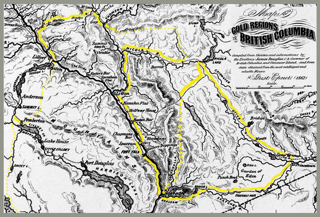
The Cariboo Road (also called the Cariboo Wagon Road, the Great North Road or the Queen's Highway) was a project initiated by the colonial Governor of British Columbia, James Douglas. The road was to be built from Fort Yale via Fort Alexandria to Barkerville, through extremely hazardous canyon territory to the interior of B.C.
|
#1 Trans Canada
|
|
1863
|
Last ferry crossing at Spuzzum. The first Alexandra Bridge built at Spuzzum (Lower Fraser Canyon), commissioned by Joseph Trutch. (Construction had commenced in 1862).
|
#1 Trans Canada
|
|
1864
|
The Chilcotin War or Chilcotin Uprising was a confrontation in 1864 between Warriors of the Tsilhqot'in (aka Chilcotin) people, and non-natives. It would become a war between the Tsilhqot'in Nation and the Colony of British Columbia. Fourteen men employed by Alfred Waddington in the building of a road from Bute Inlet were killed, as well as a number of men with a pack-train near Anahim Lake and a settler at Puntzi Lake, in Tsilhqot'in Territory.
The road, never completed, was intended to provide a new and shorter route to the gold-fields of the interior. According to Waddington, it would reduce land travel from 359 miles to 185 miles and the total days consumed in packing freight from 37 days to 22 compared to the Yale-Fraser Canyon route known as the Cariboo Road favoured by Governor Douglas. The effects of the Chilcotin War has influenced road and rail construction, including hydroelectric development, to and through the Chilcotin Plateau, for more than a century.
|
hwy # 20 (region)
|
|
1860's
|
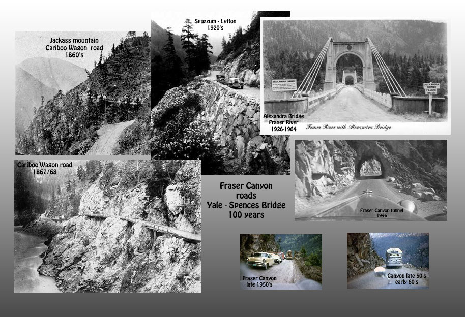
From Yale (Lower Fraser Canyon), wagons and mule teams would begin their month long, 373 mile (600 km) trek on the 18 foot (5.4 m) wide trail. The steepest ascent on the wagon road was the climb up Jackass Mountain. By losing their footing, many pack animals were killed after falling into the canyon.
|
#1 Trans Canada
|
|
1865
|
Cariboo Wagon Road was completed.
|
#1 Trans Canada #97
|
|
1873
|
The Burrard-Lillooet cattle trail or "Howe Sound Trail", was an alternate route to the coast, intending to support BC's interior cattle industry, and for boosting Lillooet's post gold-era economy. Construction began in 1873. From Lillooet, the trail would be cut along the rugged lakeshore of Seton Lake, over the Short Portage, then along Anderson Lake. The route would then follow the Douglas Trail section from D'arcy to the Pemberton valley, south to Squamish, through the North Shore mountains via via a series of "stairs" crossing the pass into the Seymour River watershed valley, south to Burrard Inlet (Vancouver).
|
#99
|
|
1877
|
The controversial Burrard - Lillooet cattle trail is completed in 4 years. The $38,000 construction cost was the most for a public works project in the Colony's history.
The majority of the 164 miles (~260 km) trail was new work. The trail width was to be just 3 ft wide, but required substantial blasting, grading, cribbing, and stone wall building. The trail had 80 bridges. As a cattle trail, the route was a failure. It was too long, too narrow and precipitous, too rough and there was not enough feed. November, 1877 was the first cattle drive of 200 head from Lillooet - the route was found to be in deplorable condition and many animals were injured enroute and had to be shot, or died after arriving on the shores of Burrard inlet. Several more cattle drive attempts were made from the Pemberton valley proved not financially viable, though the cattle trail was abandoned, it remained in use as a access trail from Pemberton to Squamish by area residents.
|
#99
|
|
1880's
|
The route of the failed road contract (Waddingtons road), was later considered for the mainline of the Canadian Pacific Railway (CPR), to connect to Vancouver Island via Seymour Narrows then south to Victoria, but Burrard Inlet was chosen for the railway's terminus-port city instead, thereby creating the City of Vancouver.
|
#1 Trans Canada
|
|
1880's
|
With the construction of the Canadian Pacific Railway (CPR), through the Fraser canyon, came the destruction of key portions of the Cariboo Wagon Road, as there was no room for both railway and road on the narrow, precipitous terrain above the river. As a result, the towns of Lytton and Boston Bar were cut off from road access with the rest of the province, other than by the difficult wagon road to Lillooet via Fountain, (above the Fraser River).
|
#1 Trans Canada
|
|
1883-1884
|
Building the CPR through the Canyon, continued extensive damage to the Cariboo wagon road. Crossings were numerous, and often the cuts or fills for the railroad grade jeopardized the road. Prior to the railways completion, in 1885, the bulk of north-bound freight moved over its lines to Ashcroft, where a new freighting and stagecoach headquarters was set up.
|
#1 Trans Canada
|
|
1885
|
CPR railway main line through the Fraser Canyon completed.
|
n/a
|
|
1894
|
The Alexandra bridge at Spuzzum, fell into disuse following the completion of the CPR in the early 1880s and much of the decking washed away in the 'Fraser flood' of 1894. The Cariboo road in was in disrepair, and almost total abandonment, hastened by flood washing away trestle work used in skirting the cliffs and bluffs.
|
#1 Trans Canada
|
|
1894-1915
|
Canadian National Railway (CNR) and CPR rail lines, are now the only transportation through the Fraser Canyon.
|
n/a
|
|
1913
|
CNR blasting along the tracks caused a series of major rock slides into the Fraser River at the Hell's Gate area, obstructing the passage. It was determined that 14 million salmon perished trying to get up river to spawn, followed by the collapse of the Fraser River fisheries what has come to be known as the "Hell�s Gate Slides". These occured in 1913 and 1914 and drastically reduced salmon runs into the interior rivers and lakes.
|
#1 Trans Canada
|
|
1912-1916
|
The Pacific Great Eastern (PGE) Railway, between Newport (Squamish) and Lillooet was constructed. Sections of the rail grade would follow, or be built on top of the original 'Cattle Trail', between Squamish and Lillooet.
|
#99
|
|
1914
|
Kettle Valley Railway Bridge constructed across Fraser River at Hope, carried railway traffic on bottom deck, highway (Automobile) traffic along the upper timber deck of the structure.
|
#1 Trans Canada
|
|
1915
|
Kettle Valley Railway (KVR) completed. (Princeton � Spences Bridge), connecting with the CPR mainline on the Fraser Canyon.
|
#5 (partial) Yellowhead - #8 Merritt
|
|
1916
|
The KVR Coquihalla subdivision to Hope, was opened through the Coquihalla canyon (North Cascades). The 61 km�s of track, between Hope and Coquihalla, originally had 43 bridges, 12 tunnels and 15 snowsheds.
|
#5 Coquihalla
|
|
1920-1924
|
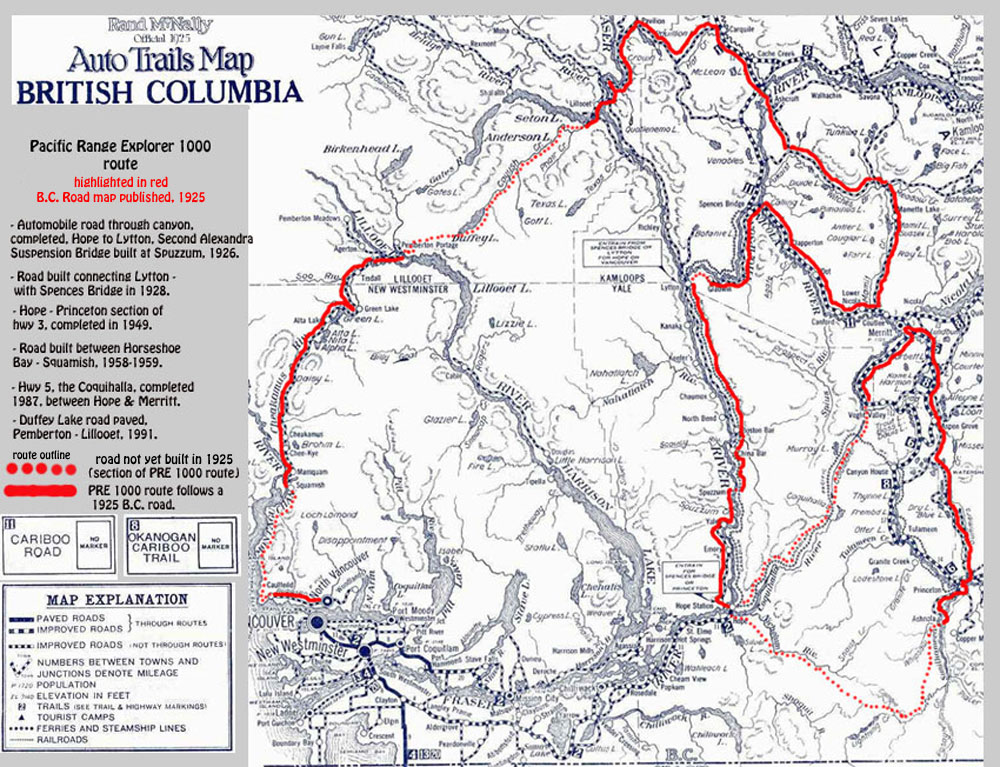
Post-WWI, increased automobile use hastens new road construction through Fraser Canyon. Road surveyed in 1920, construction of newly located section continues through 1924.
|
#1 Trans Canada
|
|
1926
|
Automobile road through canyon, completed, Hope to Lytton. The second Alexandra Suspension Bridge built at Spuzzum, on top of foundation abutments of the original. A toll booth with resident collector was established at Spuzzum. The toll started at $1, a huge sum for the late 1920s, around two hours work for a skilled tradesman, or about $40 in today�s Canadian currency equivalent.
|
#1 Trans Canada
|
|
1928
|
A road completed along the Thompson River, from Lytton to Ashcroft (via Spences Bridge - Cook�s Ferry).
|
#1 Trans Canada
|
|
1928-1949
|
The main early automobile route across British Columbia , was in the south, what is currently the Crowsnest Highway #3. The Southern Trans-Provincial Highway from Vancouver, went through Spences Bridge (what is now hwy #8 , built in 1953, followed the general NK&S rail route), to Merritt, south along the Coldwater River, then to Princeton, (initially via Coalmont).
|
#1 - #3 - #8 - #5 - #5 (region) - #5a (region)
|
|
1948
|
Highway timber deck on top of Kettle Valley Railroad bridge over Fraser River, was removed and replaced with steel T-sections. (town of Hope)
|
#1 Trans Canada
|
|
1949
|
Post-WW2, Hope � Princeton highway (#3 Crowsnest) completed in November. This provided the direct highway link from the Fraser Valley to the southern interior across the North Cascade mountains, signalling the demise of the Kettle Valley railway as the principle transportation route in southern B.C.
|
#3 Crowsnest
|
|
1953
|
Bella Coola - Chilcotin Plateau - Williams Lake road completed by local road-builders, opened officially in 1955.
|
#20
|
|
1957
|
The northern end of Highway 99 designation, was moved out of downtown Vancouver, to across the Lions' Gate Bridge and west to the village of Horseshoe Bay, following Marine Drive through West Vancouver.
|
#99
|
|
1958-1959
|
Highway 99 was re-aligned to the Upper Levels Highway and extended to Britannia Beach, being extended further to Squamish in 1959. The road section above Howe Sound was literally 'blasted through' by contracted logging road builders. Massive amounts of explosives were used. Rockslides and debris flows were common in the following years, and the threat continues to present day.
|
#99
|
|
1950�s - 1960's
|
Major highway upgrades in the Fraser canyon. The "new highway" occupied the Social Credit government of W.A.C. Bennett, and its Highways Department led by "Flying Phil" Gaglardi. During the late 1950's to mid 1960's.
|
#1 Trans Canada
|
|
1959
|
Kettle Valley Railway (KVR), ceased operation through the Coquihalla canyon to Hope.
|
#5 - #3
|
|
1950's - 1960's
|
The Fraser Canyon Highway Tunnels were constructed in the late 1950's to about the mid 1960's as part of the Trans Canada Highway project. There are seven tunnels in total, the shortest being about 57 meters, the longest is about 610 meters (one of North America's longest). They are situated between the Town of Hope and the Town of Boston Bar.
|
#1 Trans Canada
|
|
1964
|
Second Alexandra Bridge (Spuzzum) replaced, and bypassed.
|
#1 Trans Canada
|
|
1965
|
The Hope Slide, largest earth and rock slide in the history of British Columbia, closes Highway No.#3. (new paved highway section was constructed on top of slide debris)
|
#3
|
|
1965
|
�Trans-Canada Highway� completion.
|
#1 Trans Canada
|
|
1966
|
Highway #99, Vancouver to Pemberton completed. The drive from Horseshoe Bay to Whistler was an 'epic journey' in the 60's.
|
#99
|
|
1973
|
A Gravel road (~100 km), via Hanceville (hwy 20), into the Nemiah Valley (Xeni Gwet'in), is completed by the Canadian Armed Forces' Engineers.
|
#20
|
|
1978
|
The Coquihalla highway construction commenced over sections of the Trans mountain Pipeline gravel road.
|
#5
|
|
1987
|
Coquihalla Toll highway completed (Hope � Kamloops), through the Coquihalla Canyon in the North Cascade mountains.
|
#5
|
|
1987
|
BC Randonneurs 1000 km Brevet route:
Haney � Williams Lake - Haney 1000 km (This was one of the "pioneering" BC Randonneurs' 1000 km routes - the route became known as "Willy's puddle" by those riders).
|
#1/97
|
|
1990
|
�Connector� (hwy #97c/5a), over the Thompson Plateau, via Merritt to Peachland, in the Okanagan, the route constructed over the Pennask summit, where winter snowstorms and fog are common.
|
#97c - #5a
|
|
1991
|
As the forest industry encroached in the area, road access became possible. For many years the Duffey Lake Forest Service Road provided access for back road recreationalists including hunters, fishermen, backcountry skiers and backpackers. With the development of Whistler as a resort, use of the Duffey Lake Road increased. Road upgrading and paving, and provincial highway designation and maintenance, resulted in an all season road, Pemberton to Lillooet.
|
#99
|
|
1992
|
Subsequently, after paving, the Duffey Lake Road, between Pemberton and Lillooet was made part of Highway 99, and the section of Highway 12 between Lillooet and Highway 97, was re-numbered 99.
|
#99
|
|
2005
|
Hwy #20 (Bella Coola - Williams Lake), including the steep Heckman Pass section, is now an all-paved provincial hwy. The original gravel road was bulldozed through in in 1953. That linked Bella Coola on the coast, to the Chilcotin Plateau, east to the Fraser River in the Cariboo.
|
#20
|
|
2006 -
|
As part of the 2010 Winter Olympics, the British Columbia provincial government has authorized upgrading the highway to accommodate greater traffic loads, widening the highway and adding a concrete divider. Starting in 2002 a large section between Squamish and Whistler was upgraded, and as of December 2005, the first stage of southern section upgrade opened with a fully divided 4 lane section that runs from locally known "Snake Hill" to Lions Bay. Preparation and construction continues for further sections, that will result in a similar divided 4 lane route through to Whistler by 2010.
|
#99/1
|