highway road climbs - B.C. & Washington
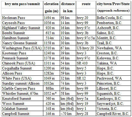
Heckman Pass, has a sustained climbing section of 1176m in 20.1 km.
The steepest sub-section gains 900m in 9.7 km.
(Heckman Pass is the overall steepest paved highway section in British Columbia).
Cayoosh Pass, ascends 1015m in 13 km via the Pemberton valley. *accumulated elevation gain (altimeter ride data)
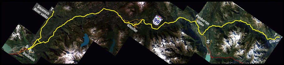
Example: An 'out and back' ride of ~260 km (Squamish/Whistler/D'Arcy/Squamish),
results in a net accumulated elevation gain of 3510m (11,500 ft).
ski area/resort road climbs - B.C. & Washington
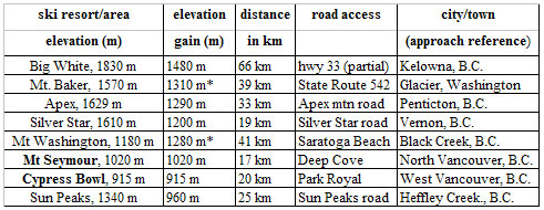
Mt Washington road, base (chain-up, elev. 155m) to summit rises 1030m in 17 km, with a maximum grade of 14% in the first kilometer, the full distance has an overall average grade of 8.4%. There is an elev. loss (descent) of 100m on the climb, resulting in a net elevation gain of 1280m. Cypress Bowl road climbs ~750m in 11 km from the District Works yard at ~km 2, Cypress Bowl road to power lines at Hollyburn ridge.
Mt Seymour road climbs 905m in 12 km from the base (gate house) to the upper parking lot. Mount Baker hwy. (SR 542) is a classic road climb to Artist Point, via the town of Glacier, Wa.
* accumulated elevation gain