|
Here's an interactive view of the area, courtesy of Google maps:
View Larger Map
|
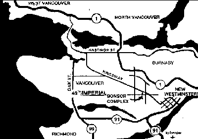
Suggested directions from Washington state:
- Head north on I-5.
- Take Exit 275 just before the Peace Arch border crossing, 2 miles to the Pacific Highway Truck border crossing (they let cars go through too). This takes half the time of the Peace Arch crossing.
- Always have the address of where you are staying with you at the border in case they ask.
- North of the border you are on Hwy 15. The border is 0 (zero) Ave. Proceed to 8th Avenue and turn left.
- It is approx 1 mile to Hwy 99, bear right onto Hwy 99 going North.
- 8 miles later take the right exit onto Hwy 91.
- Go 7 miles (crossing the Alex Fraser Bridge).
- Stay in the right lane for Hwy 91A.
- Go 1 mile.
- Get in the LEFT LANE, cross the Queensborough Bridge STRAIGHT onto Marine Way west.
- Go 2.7 miles on Marine Way.
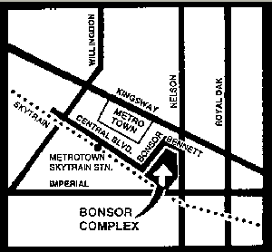
- Pass the cathedral-style church and take the next right onto Nelson (SMALL SIGN!).
- Go uphill, 1.6 miles to Imperial.
- Turn left, then right at Central, then right again into Bonsor's south parking lot.
Or continue around the building for the back entrance to the main (east) lot.
To return:
- Follow Nelson 1 mile to Marine DRIVE.
- Turn left.
- Go 1 mile.
- Turn right at Byrne.
- Go 0.3 miles.
- Turn left at Marine WAY.
|