| Home | Location | History | Photographs | Gibby’s Field Group (2000–2001) | Gibby’s Field Subcommittee (2006–) | Documents | Links | Contact |
Cedar Cottage, Vancouver, British Columbia, Canada
| Home |
1. Gibby's Field City Lots Acquired by Vancouver Park Board
1.1. Gibby's Field Staff Report Approved Unanimously at Park Board Meeting on Monday 27 February 2023
Monday 27 February 2023: The Commissioners of Vancouver Park Board unanimously approved the only staff report on the meeting agenda tonight – "Naturally Managed Park Plan – Gibby’s Field" (for decision).
The upshot is that, as per recommendation C in the report, the three City lots at 1454, 1458, and 1462 East 18th Avenue (known to those locally as "Gibby's Field") are now to be consolidated as a "permanent park."
1.2. Gibby's Field Staff Report to Be Presented at Park Board Meeting on Monday 27 February 2023
Tuesday 21 February 2023: The agenda was published today for the Park Board meeting at 6:30pm on Monday 27 February. Included in the agenda is the 6-page staff report "Naturally Managed Park Plan – Gibby’s Field" (for decision).
The staff report makes the following three recommendations:
-
A. THAT the Vancouver Park Board approve the draft concept plan for the new park site known as Gibby’s Field, and direct staff to design and implement the path, rainwater retention, and vegetation work as described;
-
B. THAT the Vancouver Park Board direct staff to work with the City of Vancouver Engineering Department staff to include this work as a part of a grant claim for federal funding assistance; and
-
C. THAT the Vancouver Park Board direct staff to work with City staff to consolidate the parcels at 1454, 1458, and 1462 East 18th Avenue as a single park parcel and designate the consolidated parcel as permanent park.
You can request to speak at a Park Board meeting for up to 5 minutes, speaking either over the phone (which is encouraged) or in person. You can make a request to speak either by sending a request to the e-mail address [email protected] or by phoning 604-257-8158 (see Speak at a Park Board meeting about an agenda item). Requests must be received by noon on the day of the meeting.
Alternatively, you can e-mail your support of the staff report to the Park Board Commissioners via the e-mail address [email protected].
1.3. Gibby's Field Proposed to Become a Park Owned by Park Board (January 2023)
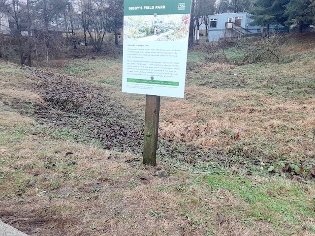
Tuesday 17 January 2023: Gibby’s Field, a place where two Vancouver creeks once met (Gibson Creek and Davey Creek), lies on three city lots in Kensington–Cedar Cottage on East 18th Avenue: 1454, 1458, and 1462. These city lots have been transferred to the Park Board and are to become the "Gibby's Field natural park" according to a City of Vancouver (CoV) web page about the planned park (see vancouver.ca/gibbys-field).
To quote from the just-mentioned CoV web page:
-
The Park Board has been exploring options to enhance Gibby’s Field as a naturally-managed area and build on the community vision developed by the Gibby’s Field Group and subcommittee.
The City has provided a contact e-mail address ([email protected]) for the "Gibby's Field natural park" project.
Signs have been placed at Gibby's Field this week by the City about the planned park (the following images are courtesy of Chad Townsend):
|
|
|
 |
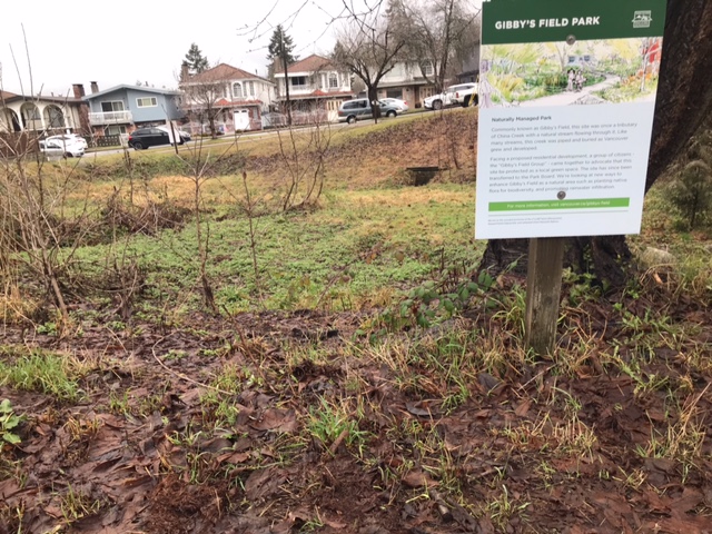 |
A report about the Gibby's Field natural park is to be presented at a future Park Board meeting. Members of the public will be allowed to briefly speak to Park Board at the meeting about the park report. The presentation could be as early as next month (February 2023); there are two Park Board meetings in February, at 6:30pm on Monday the 13th and 27th. (The 2023 Park Board meeting schedule can be found at parkboardmeetings.vancouver.ca/2023.)
2. About Gibby’s Field
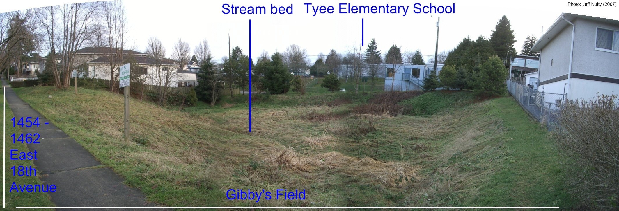
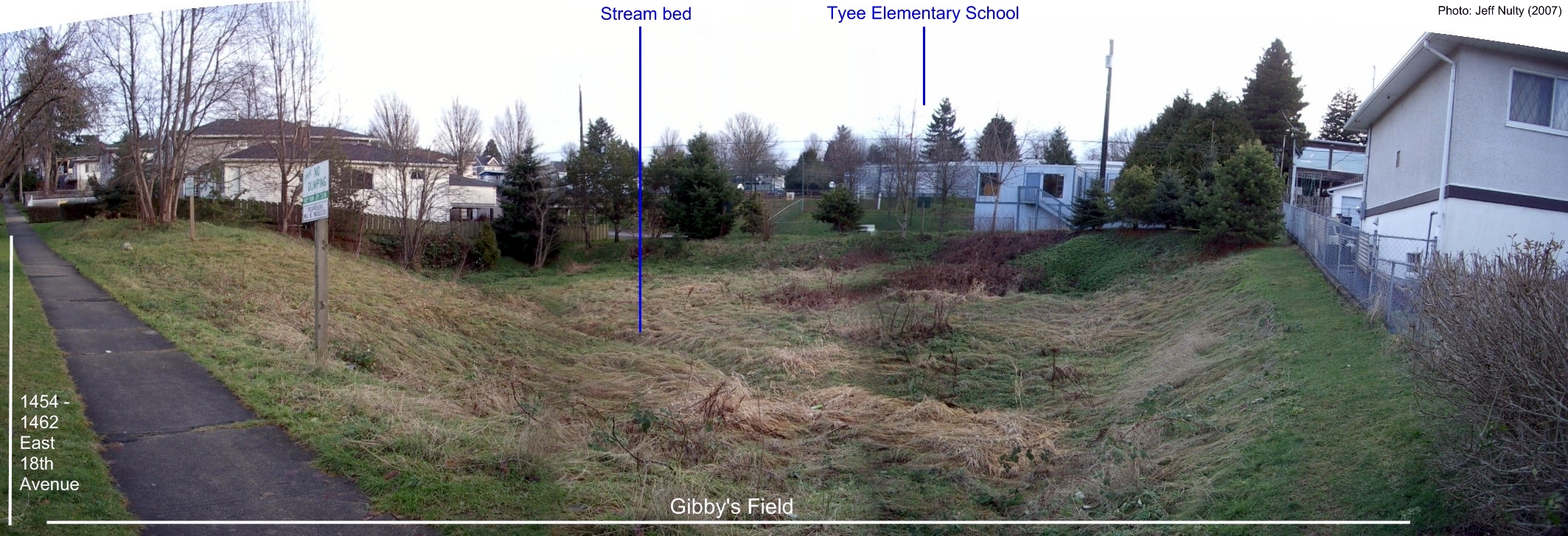
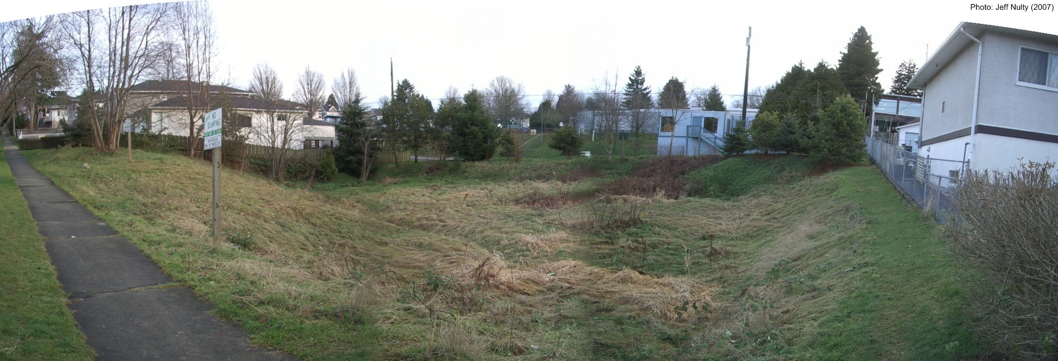
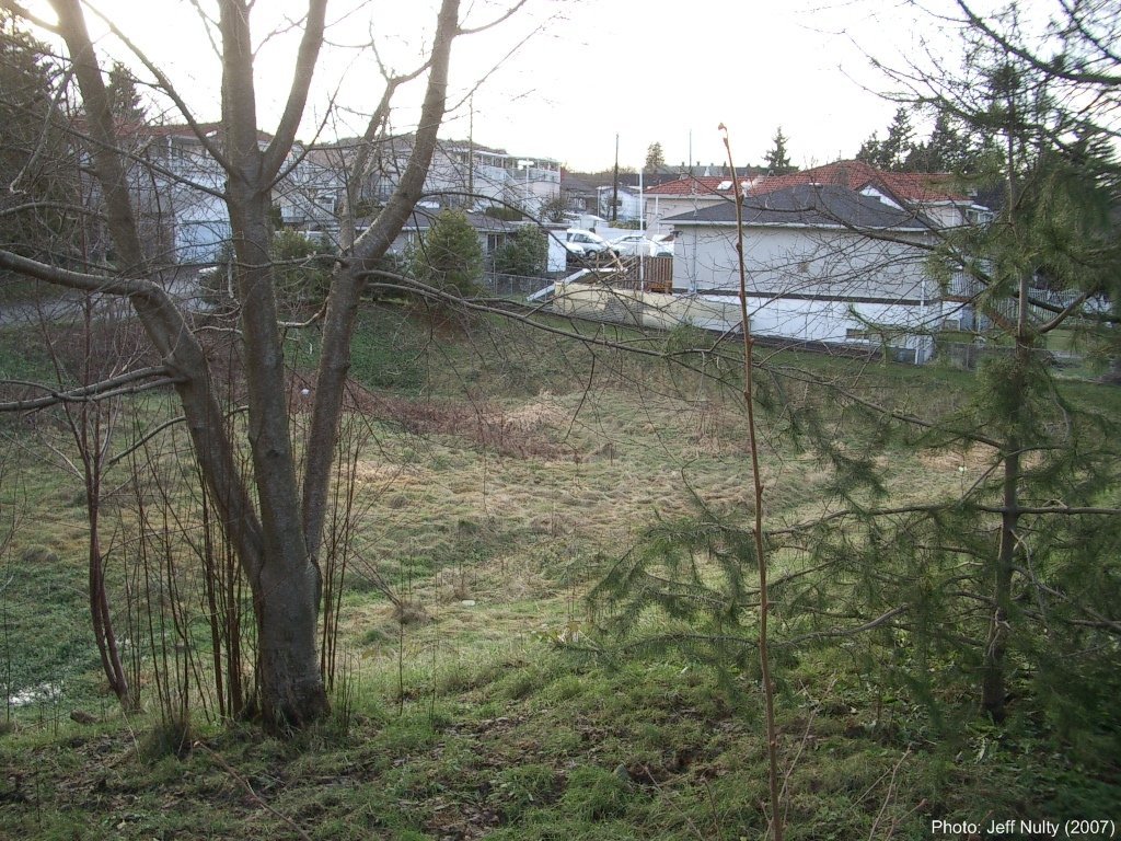
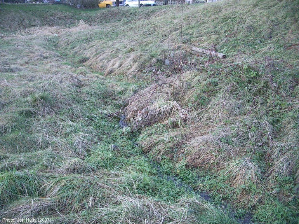
• Location of Gibby’s Field. Gibby’s Field lies in a dip on the 1400 block of East 18th Avenue in the neighbourhood of Cedar Cottage in Vancouver. Gibby’s Field is just down the hill from Tyee Elementary School, in a residential area. It’s on three city lots on East 18th: 1454, 1458, and 1462. The streets to the east and west of Gibby’s Field are Dumfries Street and Knight Street. See maps of Gibby’s Field, Cedar Cottage, and Vancouver on the Location web page.
• Gibby’s Field is owned by the City and has never been developed. Remarkably, the City of Vancouver owns Gibby's Field in the form of three city lots.
Even more remarkably, these city lots have never been developed!
If you go by the lots, you will see that they look like a pasture and contain a stream bed that follows the same path as an old creek, Gibson Creek.
See the Gibby’s Field photographs below and other photographs of Gibby’s Field.
|
|
|
3. History Documents (November 2009; January, April 2010)
The following documents about Gibson Creek and Gibby’s Field were published in late 2009/early 2010:
-
November 2009:
History booklet (in PDF) “Historical Walking Tour of Gibson Creek Through Kensington–Cedar Cottage.” 32 pages (1.25 MB download).
- 3 January 2010:
History article (in HTML or PDF) “Gibby’s Field, Moses Gibson, and Gibson Creek, Revised.” Two pages.
- 13 April 2010:
“Map of schools, colleges, and the China Creek watershed” (in PDF). Three pages (1.31 MB download).
The 2009 history booklet contains a self-guided tour of Gibson Creek and China Creek past King Edward Village, Gibby’s Field, and Vancouver Community College, to where China Creek used to empty into False Creek. Before reading the booklet, it is a good idea to first read a brochure from the False Creek Watershed Society called “False Creek’s Watershed: Then & Now” (available as a PDF here). The brochure helps put the booklet in context — in effect, the booklet is a study of the eastern end of the map in the brochure.
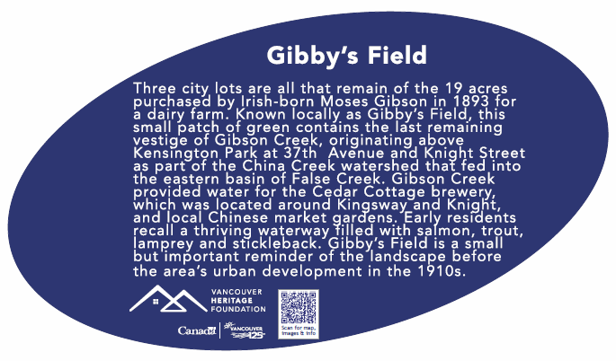
4. Historical Plaque Dedication (May 2013)
In August 2011, Gibby’s Field was announced as one of 125 Vancouver sites to receive a historical plaque as part of the Vancouver Heritage Foundation’s “Places That Matter” project. This project evolved from the City of Vancouver's 125th Anniversary celebrations in 2011.
Three events took place Friday 3 May 2013 to mark the installation of the plaque at Gibby’s Field.
The main event was the dedication.
Those in attendance included seniors Olive Cairns and Florence Anderson who are both in their 90s and remember Gibson Creek, which ran through Gibby’s Field as late as 1944, and descendants of one-time local landowner Moses Gibson, who gave his name to Gibby’s Field.
Those in attendance also included Vancouver–Kingsway MP Don Davies, City of Vancouver Councillor Andrea Reimer, and and Mrs. Lublow’s grade 4/5/6 class from nearby Tyee Elementary School.
A permanent link to the events of 3 May 2013 can be found at www.vcn.bc.ca/gibbys/plaque.htm.
|
|
|
5. History
5.1. Moses Gibson (1850–1937)
“Gibby’s Field” takes its name from its former owner, who was called “Old Man Gibby” by the neighbourhood children. Old Man Gibby’s real name was Moses Gibson. He was born in 1850 and lived in Cedar Cottage from 1893 until his death in 1937 at the age of 87. The lots are known to this day as “Gibby’s Field” by local people.
Moses Gibson used to be a major property owner in Cedar Cottage. He was also a prominent local citizen. He was an early trustee of the first school in the Kensington–Cedar Cottage area which began in 1892, D.L. 301 School. He was a city councillor in 1893, for South Vancouver.
And he ran a dairy farm for many years, helped especially by one of his ten children. His farm house and home was on East 20th Avenue, just east of Knight. East 20th Avenue used to be known as Gibson Road until 1910.
5.2. Gibson Creek and Davy Creek
Gibson Creek was named after him. Gibson Creek used to flow down the hill from Kensington Community Centre down the hill, through Kingcrest Park and under King Edward Village at Kingsway and Knight. Gibson Creek met another major local creek, which was known as Davy Creek, and then flowed across Gibby’s Field. The combined creek then flowed down across Clark Park before joining China Creek, which flowed into the east end of False Creek.
5.3. Local People Remember Moses Gibson and the Creeks
There are people living in Kensington–Cedar Cottage today who remember Gibby’s Field when the creek used to flow through it, and even remember Moses Gibson! Some residents remember that Gibby’s Field was a magnet for children for miles around in the 1920s, and more recently. Children used to treat Gibby’s Field like a local park. They would gather there to have picnics by the creek, to fish in the creek, and to pick crab apples and hard pears from a nearby orchard. But you had to watch out because some of the boys used to have fruit fights and you had to watch out for Moses Gibson’s dairy cows who used to graze there.
Learn more about the history of the Gibby’s Field.
|
|
|
6. Gibby’s Field Group (2000–2001)
In 2000–2001, a group of local citizens, who called themselves the Gibby’s Field Group, got wind that the City of Vancouver was planning to develop the three City lots. They raised awareness about the historical and ecological value of Gibby’s Field and succeeded in getting a moratorium placed on development of the lots.
Learn more about the work of the Gibby’s Field Group.
7. Gibby’s Field Subcommittee (2006–)
In 2006, a second group of citizens rediscovered Gibby’s Field. This group is known as the Gibby’s Field Subcommittee and is affiliated with the False Creek Watershed Society and the Kensington–Cedar Cottage CityPlan Committee. The Gibby’s Field Subcommittee is raising awareness about Gibby’s Field. The subcommittee seeks to:
Learn more about the work of the Gibby’s Field Subcommittee and photographs of Gibby’s Field events organized by the subcommittee.
|
|
|
8. More information
If interested, you can obtain more information about Gibby’s Field by visiting the Documents and Related Links pages on this website, and contacting the Gibby’s Field Subcommittee.
|
Creative Commons Attribution
2.5 Canada License |

|

Top |
Number of visits: 21279 |
Last updated: 27-Feb-2023 |